




Broken Hill NSW: Titles, Mineral Occurrences & Surface Mineral Map Pack (NASA EMIT, GeoTIFF, GPKG, KMZ)
Broken Hill district, far-west New South Wales, Australia: a tenure-and-surface-mineralogy screening pack for the Broken Hill Pb-Zn-Ag district. It gives you a ready-to-use, documented set of mapped SURFACE layers for a 40 x 40 km tile (including the town of Broken Hill, the Barrier Ranges and the Silverton - Mundi Mundi plain), so you can see in your own GIS in minutes who holds the exploration and mining titles, what is already recorded in the ground, and what the satellites see at the surface.
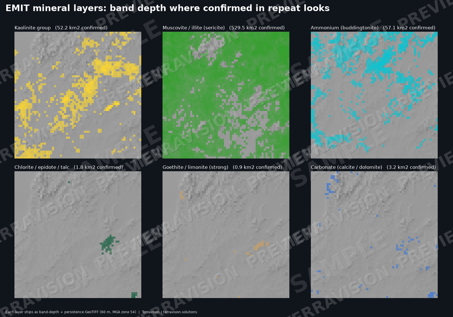
NASA EMIT is the centrepiece. The ISS-based EMIT imaging spectrometer identifies minerals from their absorption features. We processed 16 clear-sky looks (2023-2026, median 13 looks per pixel) into 60 m multi-scene mosaics for 12 mineral groups, each with band depth and persistence (how many looks agree). A split-half agreement check shows which layers to trust. Confirmed areas in the tile: muscovite/illite 530 km2, kaolinite 52 km2, ammonium/buddingtonite 57 km2; smectite, goethite/limonite, carbonate and chlorite/epidote/talc are tiny (0.5-3 km2). Hematite is detected over almost the whole tile (red regolith) and carries little information on its own. No alunite, pyrophyllite/diaspore, jarosite or gypsum is confirmed anywhere in the tile: this is a metamorphic, deeply weathered district, and the EMIT picture is largely rock type and regolith - the guide says so plainly.
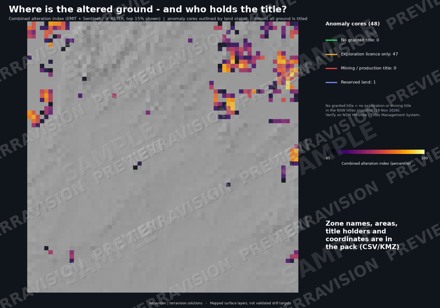
Add Sentinel-2 and ASTER clay, iron, carbonate and silica indices at 20 m, a combined alteration index with 48 cores, 48 footprints and 481 EMIT mineral patches (all with coordinates, title holders and land-status percentages), 126 DEM lineaments checked against Geoscience Australia mapped faults, and 111 fault intersections.
Titles and known occurrences (NSW MinView, CC BY 4.0): 80 granted exploration and mining titles (52 exploration licences, 11 mining leases, 10 consolidated mining leases, 4 mining purposes leases, 3 exploration (prospecting) licences) with holder, grant, expiry and renewal dates, 5 title applications, 36 titles flagged as expiring within 24 months, and 1,701 NSW mineral occurrences (lead-silver-zinc, copper, industrial minerals and more) with commodity, host rock, location accuracy and the title at each point, plus 2 operating-mine records.
Land status / no-go ground: every 20 m pixel is classed as no granted title (11 km2, 0.7 %), exploration licence only (1,432 km2, 90 %), mining / production title (81 km2, 5 %) or reserved land (76 km2, 5 %). The constraint layer holds 9 polygons: timber and water-supply reserves (Stephens Creek and Umberumberka reservoirs), the Barkandji Native Title determination area and registered ILUAs. Native Title and ILUA areas do not stop exploration; they mean the future-act regime and any ILUA terms apply. No national park or other CAPAD-listed protected area and no Commonwealth or Defence land is inside the tile (nearest national parks 66 km and 78 km away).
What the overlays say, honestly: almost all of this ground is already under exploration licence, so this pack is a screening tool for who holds what and when titles expire (useful for farm-in, joint-venture and ground-release planning), not an open-ground finder. The zones and patches are muscovite- and kaolinite-enriched surface material that is as likely to be metamorphic basement or regolith as hydrothermal alteration.
Everything is in GDA2020 / MGA zone 54 with a full layer index, and a 10-page PDF explains the method, how to use it in QGIS / ArcGIS / Google Earth, what the layers can and cannot show, and the data credits and licences.
Who it's for: exploration geologists and consultants screening the Broken Hill region; juniors and investors doing desktop tenure review; GIS analysts; students and teachers working with EMIT / ASTER / Sentinel-2.
What's inside:
- 47 GeoTIFF layers (EMIT 60 m: 24 mineral band-depth / persistence layers + class map + argillic and iron scores; Sentinel-2 / ASTER 20 m indices; combined alteration index incl. an outside-mining-leases-and-reserves version; land-status class; title count; hillshade; structure density indices)
- GeoPackage (12 layers) + 12 GeoJSON: alteration cores, footprints, EMIT patches, DEM lineaments, mapped faults, fault intersections, granted titles (80), title applications (5), mineral occurrences (1,701), operating mines (2), land-status polygons, reserved-land / Native Title / ILUA areas (9)
- CSV tables with lon/lat and MGA coordinates, titles with holders and expiry, occurrences, scores, land status, EMIT agreement checks, scenes used, protected-area and Commonwealth-land checks, layer index
- 3 Google Earth KMZ files (alteration pack with raster overlays; structure; minerals, titles and land status)
- 10-page PDF guide: method, GIS use, limits, data sources and licences
- Size: about 137 MB download (~142 MB unzipped)
Important: These are mapped surface layers - NOT drill targets, not a resource or reserve estimate, not a JORC or technical report, and not investment, legal or exploration advice. Satellite spectra see only the top microns of the ground, so they map clays, micas, carbonate and iron oxides but do NOT detect lead, zinc, silver, copper, gold or any commodity, and say nothing about what is beneath the surface. A mineral pixel is a spectral match, not a grade, and the layers have not been validated by drilling, sampling or field work. Micaceous schist, weathered rock, regolith and mine dumps can mimic what you are looking for. Title data are an approximate snapshot (NSW MinView, 19 Nov 2026) - verify on MinView and the Titles Management System before relying on them. NSW occurrence records are historical and positions are approximate. Land-status, reserve and Native Title boundaries are approximate screening layers, not legal title, heritage or access records.
Specs: CRS GDA2020 / MGA zone 54 (EPSG:7854); extent E 514000-554000, N 6447000-6487000 (40 x 40 km, about 31.9 S, 141.35 E); EMIT 60 m, Sentinel-2/ASTER 20 m; formats GeoTIFF, GPKG, GeoJSON, CSV, KMZ, PDF. Works in QGIS, ArcGIS, Google Earth, Global Mapper, Python/R.
Licence: single-user licence for your own internal and commercial use; no resale or redistribution of the pack. Third-party data (NSW, Geoscience Australia, NNTT: CC BY 4.0; NASA; Copernicus) are credited in the guide.
Delivery: instant download after purchase (one ZIP).
FAQ
- Does it tell me where the lead, zinc, silver or copper is? No. Satellites map surface minerals only. The pack shows the recorded NSW occurrences and who holds title, plus what the surface minerals look like.
- Does it tell me where to drill? No. It is not a drill-target product and is not exploration advice.
- Is there open ground to apply for? Almost none: about 90 % of the tile is under exploration licence. The pack shows holders and expiry dates so you can see what may become available or who to approach.
- Does it show Native Title, reserves and protected areas? Yes: reserves, the Barkandji Native Title determination and ILUA areas are mapped, and the tile is checked against CAPAD and Commonwealth/Defence land (none inside). Freehold, pastoral-lease and Aboriginal Land Council land and heritage sites are not mapped.
- How accurate are the mineral maps? Each mineral has an agreement score (guide section 3). Treat smectite, goethite, carbonate and chlorite as indicative; muscovite largely reflects metamorphic rocks here.
- Which software do I need? Any GIS that opens GeoTIFF/GeoPackage, or Google Earth for the KMZ.
- Refunds? Because this is an instant digital download, sales are final once downloaded. If a file is faulty or won't open, email chris.tps.info@gmail.com, use the contact form at terravision.solutions, or send a Payhip message, and we will fix it or refund you.
Pricing (USD): single-user licence $245 launch price (list $345); team licence (up to 5 users) $595; academic / student licence $99. All three are the same download and differ only in licence terms.
Terravision | terravision.solutions